Site Analysis in Architecture: A Step-by-Step Guide

Site analysis is one of the first and most important stages of the architectural design process. Before developing a building concept, architects need to understand the physical, environmental, and contextual conditions of the land.
An effective site analysis in architecture goes beyond identifying plot dimensions and boundaries. It examines topography, sunlight, wind, accessibility, surrounding buildings, and other factors that may influence architectural decisions.
By organizing this information into clear diagrams and observations, architects can identify opportunities, recognize constraints, and establish a more informed starting point for design.
In this guide, we explain how to conduct architectural site analysis step by step and how to translate the findings into useful design information.
1. Understand the Purpose of Architectural Site Analysis
Architectural site analysis is the process of collecting and interpreting information about a specific location before developing a design proposal.
Its purpose is not simply to document existing conditions. The information should help architects understand how the site may influence the building.
For example, a steep slope may affect the building's position, ground floor levels, and access arrangements. Nearby buildings may influence daylight, privacy, and views.
Similarly, existing roads and pedestrian connections can affect the location of entrances.
A useful site analysis should therefore answer two fundamental questions:
- What conditions and limitations exist on the site?
- How might these conditions influence architectural design decisions?
The answers provide a foundation for developing appropriate design strategies.
2. Analyze Site Location and Surrounding Context
Begin by understanding the location of the site within its wider environment.
A building does not exist independently of its surroundings. Its relationship with nearby roads, buildings, public spaces, and infrastructure can influence the architectural proposal.
Study the Urban Context
Identify the surrounding land uses and building types.
Consider whether the site is located in a dense urban area, a residential neighborhood, or a less developed environment.
Observe neighboring building heights, setbacks, and general development patterns.
These characteristics can help establish the relationship between the proposed building and its surroundings.
Identify Important Connections
Study the site's relationship with nearby streets, pedestrian routes, public transportation, and important destinations.
Connections to schools, commercial areas, public spaces, or transportation facilities may be relevant depending on the project type.
Record Views and Privacy Conditions
Identify significant views from the site and areas where neighboring buildings may create privacy concerns.
These observations can influence window placement, outdoor spaces, and building orientation during later design stages.
3. Examine Topography and Site Geometry
Topography is a fundamental part of architectural site analysis because ground levels influence building placement, access, drainage, and construction.
Study Site Boundaries and Dimensions
Start by identifying the plot boundaries, dimensions, and approximate area.
Use reliable survey information where available, especially when developing drawings that require accurate measurements.
The geometry of the site may influence the possible building footprint and circulation arrangements.
Analyze Ground Levels and Slopes
Contour lines and spot elevations help explain changes in terrain.
A relatively flat site may provide greater flexibility for certain building arrangements, while a sloping site can create opportunities for split levels, stepped forms, or different entrance elevations.
However, sloping terrain may also introduce challenges related to accessibility, excavation, retaining structures, and drainage.
Identify Existing Physical Features
Record relevant existing features such as retaining walls, utilities, drainage channels, significant vegetation, and built structures.
These elements may need to be preserved, accommodated, or addressed during the design process.
4. Evaluate Sunlight, Wind, and Climate
Environmental conditions can significantly influence architectural design.
A good site analysis considers how the building may respond to the local climate rather than treating environmental factors as secondary concerns.
Analyze Sun Path and Solar Exposure
Study the sun's movement throughout the day and across different seasons.
Identify areas receiving direct sunlight and locations affected by shadows from surrounding buildings or terrain.
These observations can help inform building orientation, window placement, shading strategies, and outdoor space design.
Examine Prevailing Winds
Consider the prevailing wind directions and their seasonal variations.
Wind patterns may influence natural ventilation opportunities, entrance locations, and outdoor comfort.
Local topography and surrounding buildings can also affect airflow, so regional wind data should be interpreted in relation to the actual site.
Consider Additional Climate Factors
Depending on the location, relevant factors may include temperature, rainfall, humidity, snow, and exposure to extreme weather.
These conditions can influence building form, material selection, drainage strategies, and the relationship between indoor and outdoor spaces.
5. Analyze Access and Circulation
Access and circulation analysis examines how people and vehicles approach, enter, and move around the site.
Identify Existing Access Points
Locate adjacent roads, sidewalks, entrances, and possible connections to the surrounding circulation network.
Consider which boundaries offer practical opportunities for building access.
Study Pedestrian and Vehicle Movement
Observe how pedestrians and vehicles move around the site.
Identify important movement directions, potential conflicts, and connections to nearby destinations.
For larger projects, service access and emergency vehicle requirements may also need to be investigated.
Consider Accessibility
Changes in ground level, existing paths, and site geometry may affect accessible routes.
Accessibility should be considered during site analysis so that future design proposals can respond to these conditions from the beginning.
6. Review Planning Regulations and Site Constraints
Physical analysis should be supported by an understanding of the regulations and restrictions affecting the land.
Depending on the jurisdiction, relevant considerations may include:
- Setbacks: Required distances between buildings and property boundaries.
- Building coverage: Restrictions on the portion of the plot that may be occupied.
- Building height: Permitted height or number of stories.
- Land use: Activities and building functions allowed on the site.
- Access and parking: Applicable provisions for vehicles, pedestrians, and accessibility.
- Environmental constraints: Protected areas, flood risks, or other site-specific restrictions.
These conditions can significantly influence the architectural possibilities of the site.
Because planning regulations differ between locations, architects should verify requirements through the relevant local authorities and project documentation.
7. Create Architectural Site Analysis Diagrams
After collecting information, the next step is to communicate the findings clearly.
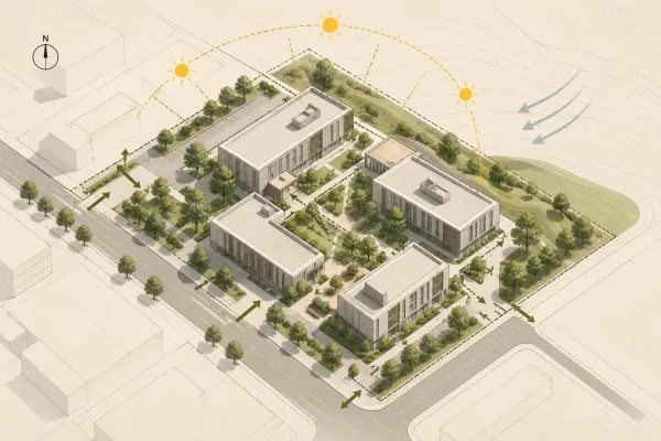
Architectural site analysis diagrams transform complex site information into visual representations that can be understood quickly.
Rather than placing every observation into a single drawing, organize the information into separate diagrams.
Useful diagram types include:
Location Diagram: Shows the site's position within the surrounding neighborhood or urban context.
Topography Diagram: Communicates slopes, contour lines, and important changes in elevation.
Sun Path Diagram: Illustrates solar orientation, seasonal exposure, and significant shading conditions.
Wind Diagram: Identifies prevailing wind directions and potential environmental influences.
Circulation Diagram: Shows pedestrian movement, vehicle access, and important connections.
Context Diagram: Highlights surrounding buildings, land uses, views, and privacy conditions.
Keep Diagrams Clear and Consistent
Use a consistent graphic language, including line weights, colors, symbols, and labels.
Avoid excessive detail that makes the main findings difficult to identify.
A good diagram should communicate a specific observation or relationship without requiring a lengthy explanation.
8. Translate Site Analysis into Design Decisions
The final stage is connecting the collected information to the architectural concept.
Site analysis becomes most useful when its findings influence actual design decisions.
For example:
- A significant slope may suggest a stepped building arrangement.
- Strong sunlight exposure may influence shading and window design.
- An important pedestrian connection may inform the main entrance location.
- A desirable view may influence the orientation of primary living spaces.
- Noise from an adjacent road may affect the organization of indoor and outdoor areas.
These are potential design responses rather than universal solutions. Each decision should be evaluated alongside the project's functional and technical requirements.
Prepare a Site Analysis Summary
Before beginning concept development, summarize the main opportunities and constraints.
A simple table or annotated diagram can help distinguish the most important findings.
This creates a clear connection between site investigation and the next stage of architectural design.
Conclusion
Effective site analysis in architecture provides the information needed to develop thoughtful and context-sensitive architectural proposals.
By examining location, topography, climate, circulation, regulations, and surrounding conditions, architects can better understand the opportunities and limitations of a site.
Clear diagrams and concise observations help transform this information into practical design guidance.
The goal is not simply to collect site data, but to use it to make better architectural decisions from the earliest stages of the project.
Explore the Apartment Design Guide